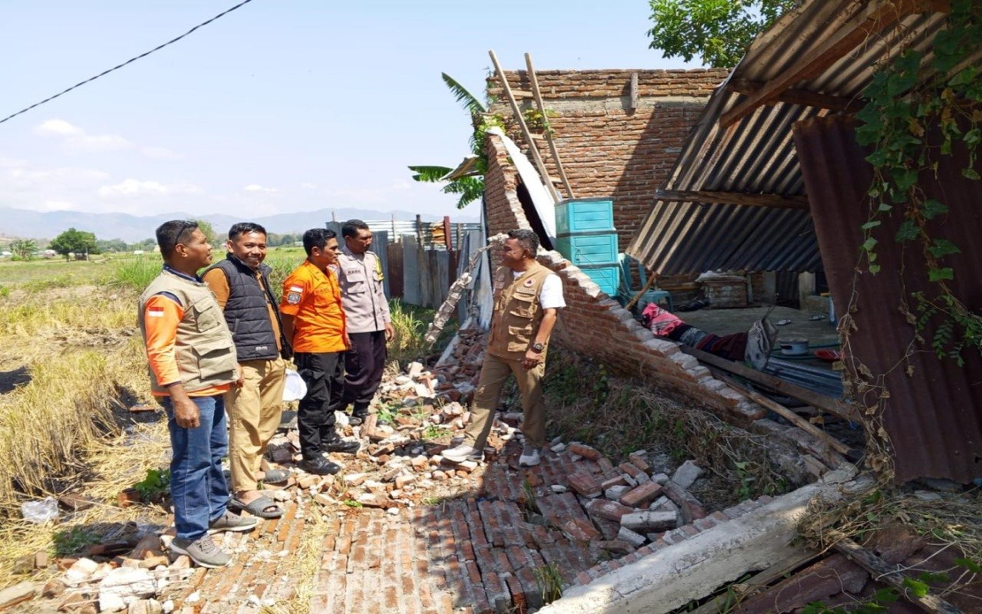
Indonesia's Flores Island in East Nusa Tenggara continues to reel from the devastating effects of a magnitude 7.7 earthquake that struck in the pre-dawn hours last Saturday, with the confirmed death toll now standing at 38 as rescue operations accelerate across the disaster zone. National Disaster Management Agency chief Suharyanto provided an updated assessment at a Saturday afternoon press briefing, revealing the scale of human suffering alongside ongoing concerns about additional casualties among those still unaccounted for in the rubble.
The tremor struck at 4.58 am local time with its epicentre positioned approximately 30 kilometres offshore from Mbay at a depth of 15 kilometres, generating powerful seismic waves that radiated across the island with devastating force. Beyond the confirmed fatalities, rescue coordinators documented two individuals with serious injuries requiring immediate medical intervention, while another eleven sustained less severe trauma. Thousands of residents acted swiftly to evacuate threatened areas independently, with approximately 2,000 having moved to safety by the time authorities began formal census operations.
What distinguishes this disaster is the particular vulnerability of communities across Flores to seismic activity, given the island's position along the Pacific Ring of Fire. The earthquake's shallow depth and moderate distance from populated areas meant that shockwaves reached residential and commercial zones with sufficient intensity to cause structural failure across multiple building types. Suharyanto underscored that numerous residents were believed to remain trapped beneath collapsed structures, making the window for successful rescue operations critically narrow and necessitating rapid mobilization of all available personnel and equipment.
Response coordination has drawn upon Indonesia's established disaster management architecture, with personnel from the National Search and Rescue Agency (Basarnas), the Indonesian military, and police forces all deployed in synchronized operations. The rescue effort represents one of the most comprehensive emergency responses the archipelago has mounted in recent months, reflecting the severity of the situation and the commitment of authorities to maximize survivor recoveries. Helicopter assets, including two rotorcraft and one fixed-wing aircraft, were pressed into service for evacuations and logistical supply missions that would prove essential given the transportation challenges created by the earthquake's secondary effects.
The infrastructure damage extends far beyond residential structures, encompassing multiple layers of the island's physical fabric. Several community health facilities sustained damage that compromised their capacity to receive and treat the injured during the critical hours immediately following the quake. Landslides triggered by the powerful earth movement blocked numerous road corridors, fragmenting transport networks and isolating some communities from rapid assistance. Airport terminal facilities and two ports serving the region experienced damage, though fortunately the runway infrastructure remained serviceable enough to permit ongoing aircraft operations essential to the relief campaign.
A tsunami warning activated immediately after the earthquake was subsequently lifted at 7.31 am following systematic sea-level monitoring that detected no abnormal oscillations that would indicate dangerous waves. This assessment provided reassurance to coastal communities but did not diminish the urgency of terrestrial rescue operations, which remained the paramount priority as rescue teams worked methodically through damaged buildings searching for survivors. The lifting of the tsunami alert, however, did permit authorities to redirect some personnel resources exclusively toward land-based rescue activities rather than dividing efforts between coastal and inland operations.
Disaster management officials acknowledged that the final accounting of human loss and physical damage would take considerable time to compile, emphasizing that Saturday represented merely the first day of response and that casualty figures would undergo continuous revision as rescue operations proceeded. This measured expectation-setting reflected hard-learned lessons from previous Indonesian earthquakes, where initial estimates frequently proved conservative before mounting to higher totals as comprehensive damage assessments proceeded over subsequent days. The Public Works Ministry deployed specialized personnel and heavy equipment to begin clearing landslide-obstructed roads, recognizing that restoration of transport links would dramatically accelerate the flow of relief supplies and rescue teams to more remote affected zones.
Logistical operations focused on establishing supply chains for essential commodities had commenced with considerable speed, reflecting Indonesia's institutional experience with rapid disaster response. Food provisions, potable water, purified drinking water containers, temporary shelter tents, electrical generators, and other critical items were being systematically distributed to communities affected by the earthquake. These supply missions, supported by the aerial assets deployed across the island, aimed to stabilize conditions among the displaced population and create conditions permitting rescue operations to proceed without simultaneous humanitarian emergencies.
For Malaysian observers and regional analysts, the Flores earthquake underscores the shared seismic vulnerability across Southeast Asia and the importance of maintaining robust disaster management capacity. The event demonstrates both the sophisticated response mechanisms Indonesia has developed and the persisting challenges that rapid-onset natural disasters present to even well-organized national systems. The broader implications for regional disaster preparedness highlight why cooperation on early warning systems, rescue equipment sharing, and standardized protocols remain critical investments for governments across the archipelago facing similar geological hazards.