Japan's meteorological authorities issued urgent warnings on Friday as the nation prepared for a rare dual-typhoon scenario, with both Typhoon Higos and Typhoon Mekkhala positioned to strike the country within hours. The Japan Meteorological Agency cautioned that Higos would approach from the Pacific Ocean and potentially make landfall over the following weekend, while simultaneously tracking Mekkhala as it bore down on the Amami region in Kagoshima Prefecture in the nation's southwest. The convergence of two tropical cyclones occurring in close succession presented an exceptionally challenging weather situation, amplifying concerns about catastrophic rainfall accumulation and compounding hazards for vulnerable populations.
The scale of the evacuation response underscored the severity of official concerns. The Fire and Disaster Management Agency reported that evacuation orders had been issued affecting more than 2 million residents distributed across 13 prefectures spanning both the Kinki and Kyushu regions. By Friday morning, local authorities across multiple jurisdictions had determined that the risk posed by anticipated flooding and ground instability necessitated the precautionary displacement of substantial population centres. In Seika, Kyoto Prefecture, authorities escalated response measures by declaring the highest level 5 emergency safety alert for certain areas following a landslide that struck during the morning hours, signalling that geological hazards were already materializing before the primary storm systems arrived.
Rainfall measurements documented the intensity of precipitation that had already inundated western Japan before the dual typhoon threat materialized. Between Tuesday and Friday morning, the Goto district in Nagasaki Prefecture accumulated 600 millimetres of rain—equivalent to nearly a month's typical precipitation in a single week. The Aso area of Kumamoto Prefecture and Ureshino in Saga Prefecture both registered exceeding 500 millimetres during the same period, creating saturated ground conditions that substantially increased susceptibility to additional landslides and debris flows. These cumulative moisture levels meant that even moderate additional rainfall could trigger cascading geological failures across hillsides and mountainous terrain.
The Japan Meteorological Agency projected that rainfall would intensify markedly as Typhoon Higos advanced northward along Japan's southern coast, with the Tokai and Kanto regions positioned to experience the most severe impacts extending through Saturday. Forecasters anticipated that the Tokai region would receive up to 300 millimetres of rain by Saturday noon, while the Kanto-Koshin area was expected to experience up to 150 millimetres. Simultaneously, Typhoon Mekkhala was advancing toward these same regions, creating the possibility that the two systems' precipitation fields could overlap, dramatically amplifying total rainfall amounts in affected areas and potentially triggering flash flooding in urban and rural environments alike.
Meteorological authorities emphasized that while both typhoons would gradually weaken into extratropical cyclones following their approach to Japan, this transition would not eliminate hazards. The transformation from tropical to extratropical systems typically occurs as these weather patterns interact with cooler mid-latitude air masses, though the process does not necessarily diminish the violence or volume of precipitation they deliver. The agency specifically urged residents to remain vigilant regarding the risks of landslides and flooding, recognizing that even weakening storms can produce catastrophic hydrological and geological consequences when ground saturation levels are already critically high.
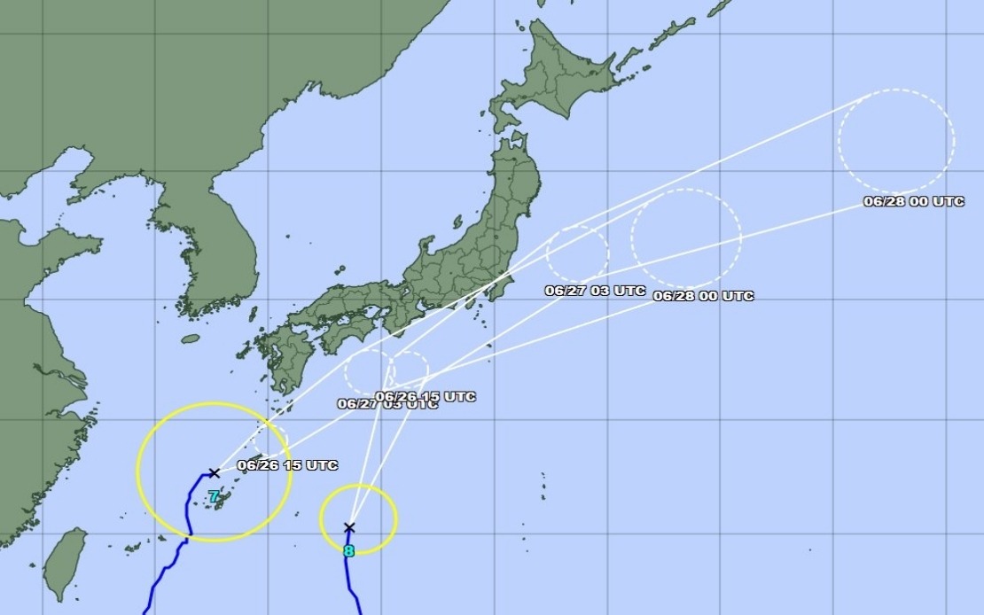
Positional tracking indicated that Typhoon Mekkhala maintained forward momentum toward the Kanto region at approximately 15 kilometres per hour as of Friday mid-morning, moving northeast from its position off Kume Island in Okinawa Prefecture. This relatively moderate forward speed suggested the system would linger over or near Japan for an extended period, potentially allowing substantial rainfall accumulation. The tracking data reinforced that while Mekkhala's intensity might eventually decline, its sluggish movement across the archipelago meant prolonged exposure to damaging winds and torrential precipitation for areas in its trajectory.
For Malaysian and Southeast Asian observers, the scenario unfolding in Japan carries particular relevance given the region's own typhoon vulnerability. The monsoon systems and tropical cyclones that affect Japan's southern islands periodically influence weather patterns across the Philippines, Taiwan, and occasionally Southeast Asia. The simultaneity of two major typhoon systems—a relatively uncommon occurrence even in Japan's typhoon-prone seasons—underscores how rapidly weather situations can deteriorate in the Western Pacific during peak season. Japanese emergency response protocols, though highly developed, were stretched by the dual-system challenge, suggesting that less-resourced nations face even greater peril when confronting such compound meteorological hazards.
The evacuation methodology employed by Japanese authorities reflected decades of accumulated experience managing typhoon threats. Rather than waiting for confirmed impacts before mobilizing populations, decision-makers opted for precautionary displacement based on meteorological forecasts. This approach prioritizes human safety over the logistical and economic disruption caused by large-scale evacuations, recognizing that predictive accuracy for severe weather events, while imperfect, provides sufficient warning for protective action. For Southeast Asian nations with comparable typhoon exposure but sometimes more limited disaster management infrastructure, the Japanese model offers instructive lessons in balancing scientific forecasting with proportionate protective responses.
The broader meteorological context suggested that Japan's typhoon season was proceeding with typical intensity. The simultaneous presence of Higos and Mekkhala reflected the basin-wide activity characteristic of June and July in the Western Pacific, when sea surface temperatures rise to levels supporting multiple concurrent tropical cyclone formations. Japanese society has developed institutional and infrastructural adaptations to manage this recurrent hazard, yet the concentration of severe weather threats within a compressed timeframe still tested these systems. For a nation where typhoons constitute a persistent seasonal phenomenon, the convergence of two systems simultaneously represented a scenario that demanded maximum alertness and resource deployment despite citizens' familiarity with tropical cyclone threats.