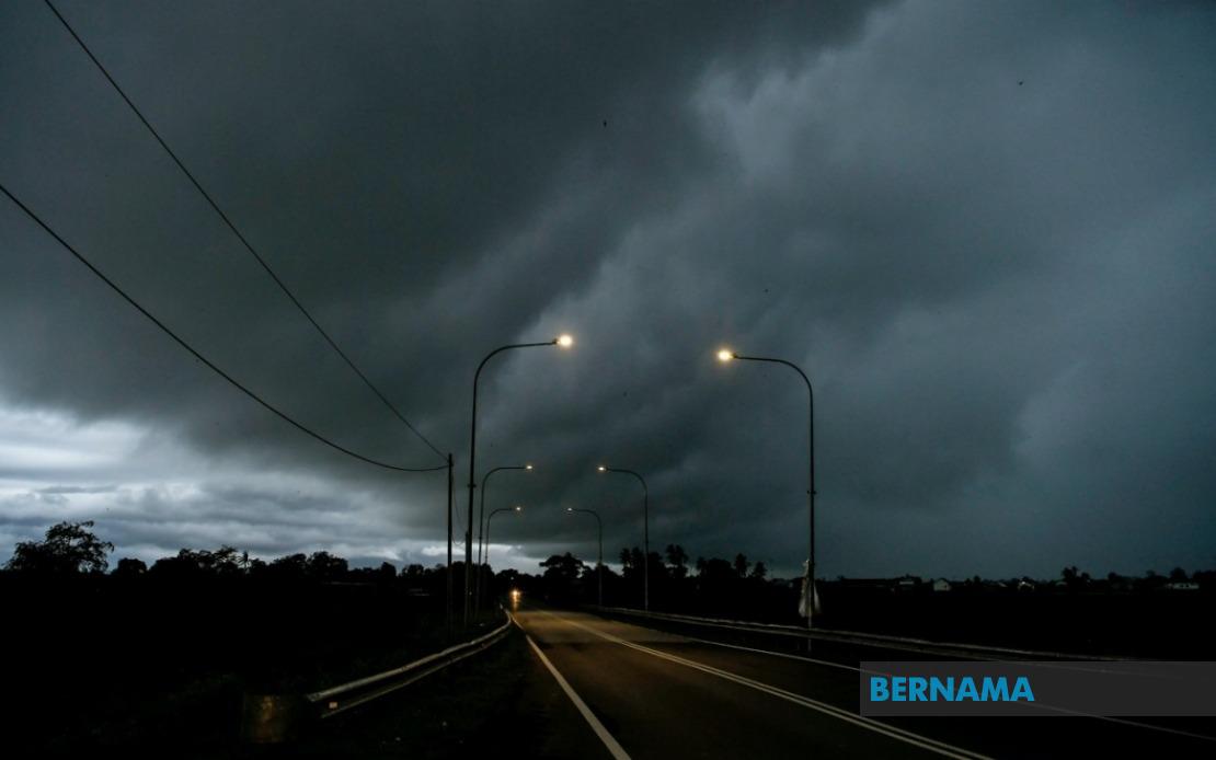
The Malaysian Meteorological Department (MetMalaysia) has issued an urgent weather alert for thunderstorms, heavy rain and strong winds sweeping across multiple regions of the country, with conditions expected to persist until 1 am on June 19. The warning encompasses six states on Peninsular Malaysia and the federal territory of Labuan, reflecting the scale of the atmospheric disturbance moving through the region. Residents and commuters in affected areas have been advised to remain vigilant and take precautions against potentially hazardous weather conditions that could impact daily activities and travel.
On the Peninsular Malaysian side, the alert covers three northern and central regions. In Kedah, three districts face the warning: Padang Terap, Sik and Baling, which lie across the state's central and northern reaches where topography can intensify rainfall. Perak's Hulu Perak district, located in the state's southern interior and characterised by dense forest cover, is similarly affected. Kelantan on the east coast experiences the broadest impact with five districts under warning—Tumpat, Pasir Mas, Jeli, Tanah Merah and Kuala Krai—suggesting a significant weather system is moving through this region. Pahang's warning applies to Jerantut in the state's interior, an area that has historically experienced disruptions from heavy tropical downpours.
Sarawak, Malaysia's largest state, faces the most extensive warning coverage with fourteen districts or subdivisions on alert. The warning stretches from Kuching and its surrounding divisions—Serian and Samarahan—through the central regions of Sri Aman, Betong, Sarikei, Sibu and Kapit to the coastal and northern areas including Bintulu, Miri and Limbang. Within these broader areas, specific subdivisions such as Pusa and Betong, Julau, Kanowit and Selangau, Bukit Mabong, Subis, Beluru and Marudi are explicitly identified as at-risk zones. This widespread coverage suggests a weather system affecting Sarawak's diverse geography, from low-lying coastal plains to highland interior regions.
In Sabah, three distinct geographical zones face the thunderstorm alert. The Interior division encompasses Kuala Penyu, a coastal settlement in the state's western section. The West Coast region includes Putatan and Ranau, both significant population centres located on the state's western flank near Mount Kinabalu. Sandakan on the east coast, covering the subdivisions of Telupid and Beluran, represents the eastern extent of the warning zone. Additionally, the federal territory of Labuan, situated off Sabah's coast and serving as a significant commercial and banking hub, is included in the alert, indicating the weather system's reach across Sabah waters and airspace.
Thunderstorms of this scale carry multiple hazards for affected communities. Heavy rainfall in interior regions like Hulu Perak and Jerantut, combined with the natural topography of these areas, can lead to flash flooding in low-lying settlements and along riverbanks. Strong winds accompanying such systems pose risks to structures, vegetation and outdoor installations, while also creating dangerous conditions for maritime activities and small craft operating in the surrounding straits and coastal waters. The simultaneous impact across such a vast geographic area from Peninsular Malaysia to the island of Labuan and across Sarawak and Sabah underscores the scale of the atmospheric phenomenon moving through Malaysian airspace.
The timing of the warning, extending through the early morning hours until 1 am, suggests the system is expected to track through these regions during the evening and night hours when visibility is reduced and emergency response operations become more challenging. Road users, particularly those travelling on highways connecting these districts, should exercise heightened caution as sudden downpours can dramatically reduce visibility and road grip. Drivers of heavy vehicles and those unfamiliar with local road conditions should consider delaying journeys or taking alternative routes if available.
MetMalaysia's decision to issue warnings across such a broad area reflects sophisticated weather monitoring systems that track atmospheric patterns and moisture convergence zones. The department's early alert mechanism allows residents time to secure loose outdoor items, check drainage systems and prepare emergency supplies. For agricultural areas, particularly in Kelantan and Pahang where farming communities are significant, such warnings enable farmers to protect crops and livestock from storm damage and potential waterlogging.
For maritime interests, the strong wind component of the warning carries particular significance. Fishing fleets, cargo vessels and ferry services operating in the Straits of Malacca, around Labuan and along Sarawak and Sabah coasts should adjust operations accordingly. Port authorities in Kuala Lumpur, Port Klang and eastern Malaysian ports would typically issue additional guidance to shipping interests during such weather alerts. Aviation operations at Malaysian airports serving the affected regions may also experience disruptions to schedules, with flights potentially delayed or rerouted to avoid the severe weather corridor.
The geographic distribution of the warning—spanning from Kedah in the north to Limbang in the east and covering both maritime and inland zones—suggests a significant atmospheric disturbance rather than a localised thunderstorm cell. Such systems often develop when moisture-laden air masses converge over peninsular and island landmasses, with geographical features like mountain ranges acting as forcing mechanisms that intensify vertical air motion and cloud development. The persistence of the warning until early morning indicates meteorologists expect the system to maintain intensity through the night hours.
Residents in the alert zones are advised to monitor official weather updates from MetMalaysia through its website, mobile application and partnership with local radio and television stations. Schools, businesses and government agencies in affected areas typically activate their weather contingency protocols when such alerts are issued, ensuring staff and students can respond appropriately if conditions deteriorate during operating hours. Local authorities in affected districts often station emergency response teams and pre-position equipment in anticipation of potential flooding or wind-related incidents.
The comprehensive nature of this alert, encompassing regions as geographically diverse as the Kedah plains, Kelantan's coastal lowlands, Pahang's forested interior and the multiple environments of Sarawak and Sabah, demonstrates how tropical weather systems can simultaneously impact vast areas of Malaysia. Understanding these alerts and responding appropriately—whether by postponing outdoor activities, securing properties or avoiding vulnerable routes—remains essential for public safety throughout the warning period.