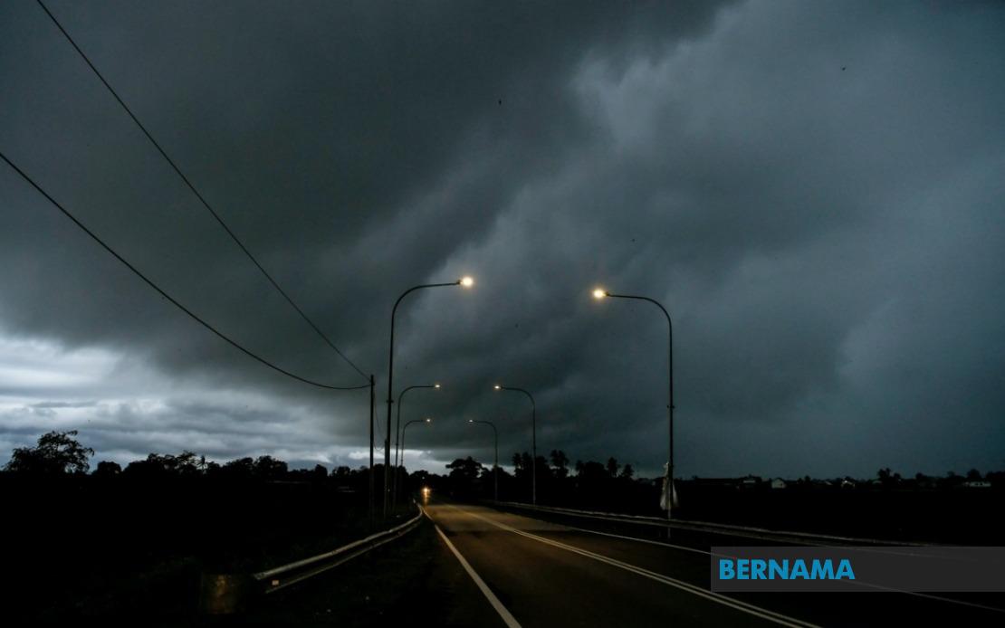
The Malaysian Meteorological Department issued a comprehensive weather alert on June 18 covering nine states and the federal territory of Labuan, warning residents to prepare for severe thunderstorms, heavy rainfall and dangerous wind conditions lasting until 9 pm that day. The advisory represents a significant meteorological event affecting millions of Malaysians across both Peninsular and East Malaysia, requiring heightened vigilance from citizens in affected districts.
In the northern peninsula, the entire state of Perlis faces the full brunt of the warning system. Across neighbouring Kedah, specific districts including the popular tourist destination Langkawi alongside Kubang Pasu, Kota Setar, Pokok Sena, Padang Terap, Sik and Baling have been flagged as danger zones. The interconnected nature of these northern lowland and highland regions means weather systems often develop across state boundaries, making the coordination of alerts across administrative lines crucial for public safety.
Moving southward through the peninsula, Perak residents in Kerian, Larut and Matang, Selama, Kuala Kangsar, Kinta and Kampar districts shouldprepare defences against incoming severe weather. The sprawling geography of Perak, encompassing both coastal and inland mountainous terrain, creates varied conditions that intensify precipitation in certain localities. Simultaneously, Cameron Highlands in Pahang—a hill station region particularly vulnerable to flash flooding during monsoon activity—sits alongside Bentong, Bera and Rompin in the warning zone. The elevation and drainage patterns of Cameron Highlands make it especially susceptible to rapid water accumulation during intense rainfall events.
Central Peninsular Malaysia experiences targeted impacts with Selangor's Hulu Langat district and two divisions in Negeri Sembilan—Jelebu and Jempol—included in the severe weather bulletin. The rapid urbanisation and river networks in Hulu Langat mean thunderstorms pose particular risks to densely populated communities and transportation corridors. In the southern peninsula, three Johor districts—Segamat, Kluang and Mersing—fall within the warning parameters, reflecting the monsoon system's broad geographical reach.
Sarawak experiences extensive coverage with multiple administrative divisions on alert. Kuching district, encompassing both the state capital's core areas and outlying Bau; the neighbouring Serian district; and Samarahan division including Asajaya experience the same severe conditions. The warning extends across the diverse terrain of Sarikei (specifically Meradong), the riverine networks of Sibu and Mukah's coastal Tanjung Manis area. Deeper inland, Song and Kapit divisions in Kapit face alert conditions alongside Bintulu's Tatau and Sebauh areas and Marudi in Miri division. Limbang completes the Sarawak coverage, demonstrating how the weather system affects the entire state from coastal zones through to inland river communities.
Sabah's interior mountain regions comprising Sipitang, Kuala Penyu, Beaufort and Tambunan join the alert roster, alongside the entire west coast region. These interior districts, many with significant indigenous populations in rural settlements, often experience isolated access during severe weather, complicating emergency response and supply chain logistics. Sandakan division's Tongod and Kinabatangan areas, characterised by wetland ecosystems and forest reserves, represent ecologically sensitive zones where extreme rainfall events trigger multiple hazard cascades from flooding to landslides.
The MetMalaysia alert system functions as a critical public information mechanism in Southeast Asia's tropical climate context, where thunderstorms develop rapidly with limited warning time. The specification of individual districts rather than blanket state-level warnings allows communities to tailor preparedness measures appropriately. For transportation networks, agricultural operations, construction sites and outdoor commercial activities, these granular forecasts enable operational adjustments that reduce accident risks and economic disruption.
The geographic diversity within the warning zones—spanning coastal areas, river deltas, highland regions and deep inland forest communities—necessitates differentiated response strategies. Coastal districts face storm surge and wind damage risks alongside flooding, whilst highland areas confront landslide dangers and flash flood velocities. River-dependent communities in Sarawak and Sabah recognise that upstream rainfall translates into rapid water level rises affecting settlements kilometres downstream, whilst urban areas like those around Kuala Lumpur and Kuching anticipate drainage system pressures and transportation disruptions.
During the period covered by this advisory, public authorities typically activate emergency response protocols. Fire and rescue services position equipment in high-risk areas, utility companies prepare for potential infrastructure damage, and health facilities alert staff to manage weather-related injuries and illnesses. School authorities and transport operators adjust schedules based on real-time conditions, whilst agricultural communities—particularly those managing water-dependent crops—monitor rainfall accumulation impacts on field conditions.
The temporal specificity of the 9 pm deadline reflects meteorological modelling confidence in system movement and intensity evolution. Weather alerts in Malaysia typically expire when confidence in forecast accuracy diminishes or when forecast conditions no longer justify alert status, allowing the system to maintain credibility rather than issuing perpetual warnings. The relatively short timeframe suggests meteorologists anticipated the system's passage rather than a persistent pattern setting in overnight.
For Malaysian readers, such alerts underscore the importance of maintaining emergency preparedness during monsoon seasons and periods of atmospheric instability. Households in affected districts benefit from having drainage clearance completed, securing loose outdoor items, ensuring vehicle fuel levels and medication supplies remain adequate, and establishing family communication plans should separated members face mobility restrictions. Businesses relying on perishable goods or time-sensitive operations incorporate weather alerts into contingency planning frameworks.
The breadth of this particular warning across nine states and Labuan reflects a major weather system affecting much of Malaysia simultaneously. The unusual extent—covering northern peninsular states, central regions, the south, and both East Malaysian states—suggests either monsoon activation or a significant convergence zone development capable of generating severe convective activity across multiple climatic zones within a single weather system.