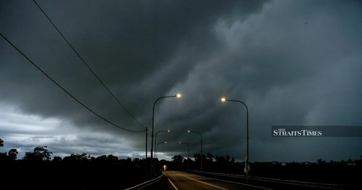
The Meteorological Department (METMalaysia) has activated a widespread severe weather warning covering the Federal Territories of Putrajaya and Labuan alongside 10 additional states, with the alert remaining in effect until 9am today. The advisory encompasses three distinct weather hazards—thunderstorms, strong winds, and heavy rainfall—that the department expects to affect the affected regions during the warning period.
Thunderstorms of this nature can develop rapidly across Malaysia's landscape, particularly during seasonal transitions and when atmospheric conditions favour convective activity. The warning reflects METMalaysia's assessment that current meteorological patterns have created conditions conducive to organised thunderstorm development, which can produce sudden gusts and torrential rainfall within short timeframes. Such systems can affect visibility for road users, disrupt outdoor activities, and pose risks to those engaged in maritime operations across the affected areas.
The inclusion of both federal territories indicates that the Klang Valley metropolitan region and its surrounding areas warrant particular caution during the alert period. Putrajaya, serving as Malaysia's administrative centre, typically sees significant daily commuter traffic and commercial activity, making weather-related disruptions potentially consequential for government operations and business continuity. Labuan, the eastern maritime federal territory, faces distinct risks from strong winds given its coastal exposure and significant shipping and offshore activities in surrounding waters.
METMalaysia's decision to specify a morning conclusion time of 9am suggests that the most severe weather activity is anticipated overnight and in the early morning hours. This timing pattern aligns with typical convective behaviour in the Malaysian region, where cooler overnight air masses and residual daytime heating create unstable atmospheric layers prone to thunderstorm development. Morning commuters and those preparing for the working day should remain alert to rapidly changing conditions before the alert expires.
The strong wind component of the warning carries particular significance for maritime operations and those utilising coastal infrastructure. Wind speeds during organised thunderstorms can exceed 60 kilometres per hour, sufficient to cause structural damage, down trees, and create hazardous conditions for small vessels. Fishing communities and offshore workers should exercise heightened vigilance and consider deferring non-essential operations until conditions stabilise.
Heavy rainfall warnings typically accompany thunderstorm alerts because convective systems produce precipitation at rates that can overwhelm drainage infrastructure in urbanised areas. Recent years have demonstrated Malaysia's vulnerability to flash flooding even in developed regions, particularly where drainage systems face capacity constraints or where topography channels water rapidly into low-lying zones. Residents in flood-prone areas should monitor water levels and remain prepared to move to higher ground if necessary.
For logistics and transportation sectors, such weather warnings create operational challenges. Road visibility reduction during heavy rain and thunderstorms increases accident risk, while strong winds can destabilise heavy vehicles and container trucks. The 9am deadline gives freight operators a clear window for assessing when resumption of normal operations becomes feasible, though wise operators often maintain heightened caution beyond the official alert period as atmospheric conditions can remain unsettled.
METMalaysia's warning system relies on real-time atmospheric monitoring and predictive modelling to identify regions likely to experience severe weather. The department continuously updates forecasts as new data arrives, meaning the alert scope may expand or contract before the 9am conclusion. Residents in the affected areas should monitor official METMalaysia announcements for any revisions to the warning parameters or geographic coverage.
The broader context for Southeast Asian weather patterns shows increasing frequency of extreme convective events, a trend meteorologists link to shifting climate dynamics across the Indian Ocean and Pacific regions. Malaysia, positioned at the meeting point of multiple monsoon systems and experiencing two main rainy seasons, remains particularly susceptible to sudden severe weather development. Preparedness and rapid public communication represent critical components of regional disaster risk reduction efforts.
For Malaysian businesses and households, thunderstorm warnings serve as practical advisories prompting prudent precautions. Securing loose outdoor items, avoiding outdoor activities during peak storm times, and ensuring vehicles are sheltered where possible represent straightforward risk mitigation measures. Commuters should plan additional travel time and exercise caution on roads, particularly in areas known for waterlogging or where traffic congestion during poor visibility can quickly deteriorate safety conditions.
The affected states and federal territories should coordinate with respective civil protection and emergency management agencies to ensure rapid response capabilities remain activated throughout the warning period. Local authorities typically position personnel strategically to address fallen trees, waterlogged critical infrastructure, and accident scenes. Clear communication channels between meteorological services, emergency responders, and the public enhance overall community resilience during adverse weather events.
METMalaysia's forecasting capabilities have improved substantially over recent decades through investment in radar technology, satellite systems, and computational resources, enabling earlier and more precise severe weather prediction. However, the inherent unpredictability of thunderstorm intensity and exact location remains a meteorological challenge requiring residents to maintain awareness and readiness even when warnings provide advance notice.
%22%2F%3E%3C%2Fpattern%3E%3C%2Fdefs%3E%3Crect%20width%3D%22100%25%22%20height%3D%22100%25%22%20fill%3D%22url(%23ph5hyagg)%22%2F%3E%3Crect%20width%3D%22100%25%22%20height%3D%22100%25%22%20fill%3D%22url(%23ph5hyagp)%22%2F%3E%3Ctext%20x%3D%2250%25%22%20y%3D%2250%25%22%20text-anchor%3D%22middle%22%20dominant-baseline%3D%22central%22%20fill%3D%22rgba(255%2C255%2C255%2C0.95)%22%20font-family%3D%22Georgia%2C%20'Times%20New%20Roman'%2C%20serif%22%20font-weight%3D%22700%22%20font-size%3D%22226%22%20letter-spacing%3D%22-0.02em%22%3EPolice%3C%2Ftext%3E%3C%2Fsvg%3E)