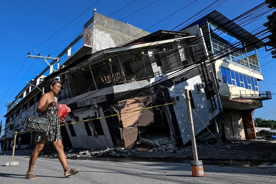
The ground beneath Arsenio Butil Jr.'s feet began to convulse on June 8 as one of the region's most powerful earthquakes in recent memory struck the southern Philippines. The fisherman and pastor, standing near his home in Glan, Sarangani province, dropped to his knees in prayer as the magnitude 7.8 quake shook the coastal area. When the tremors subsided and he opened his eyes, he witnessed something few people ever experience: the visible, dramatic transformation of the shoreline happening in real time. Vast sections of seabed that had lain beneath the ocean for millennia suddenly thrust upward, breaking the water's surface as jagged coral formations. The earthquake, generated by a shift along the nearby Cotabato Trench, claimed at least 76 lives across Mindanao and triggered devastating landslides that destroyed infrastructure and homes across the region.
The phenomenon that reshaped the Philippine coast is known to geologists as coastal uplift, a consequence of tectonic forces that occasionally catapult sections of the earth's crust skyward during major seismic events. In this instance, the Cotabato Trench—which runs as close as 50 kilometres off Mindanao's shore and marks a boundary between colliding tectonic plates—generated enough force to lift the seabed by approximately two metres. This vertical displacement extended the shoreline by as much as 200 metres in some locations, according to initial official assessments. The affected zone stretches across nearly 100 kilometres of coastline, fundamentally altering the geography that communities have known throughout their lifetimes. For residents accustomed to reading the patterns of tides and knowing every rock and reef in their fishing grounds, the overnight transformation has rendered their environment unrecognisable.
Butil Jr. described the moment when he witnessed the dramatic sequence of water movements that preceded the permanent coastal change. The seawater receded from the shore, a phenomenon that sometimes precedes dangerous tsunami waves in seismically active regions. Then, as mysteriously as it had withdrawn, the water returned, only to recede again. This pattern repeated three or four times over the course of the earthquake's main shock and its immediate aftermath. The cyclical movement of the ocean confused and terrified residents, many of whom had no formal training in recognising tsunami warning signs. As the water movements continued, Butil Jr. observed the devastating toll on marine life: fish, disoriented and gasping for air in the turbulent waters, began to die and float to the surface. The natural disaster had not merely reshaped the land but had created an ecological shock that killed countless creatures dependent on the coastal ecosystem.
Nane Danlag, a specialist at the Philippines' seismology centre, explained the permanence of the coastal transformation when interviewed in General Santos City. The newly exposed seabed, she stated, represents the community's new coastline—a stark geological reality that will not reverse. This assertion carries profound implications for disaster planning and reconstruction efforts, as authorities must accept that the pre-earthquake geography will never return. Danlag contextualised the event within a longer historical timeframe, noting that such crustal movements have been occurring for thousands of years along this tectonically active zone. The Cotabato Trench itself is a region of persistent seismic activity; just months before the June 8 earthquake, the area experienced a seismic swarm comprising thousands of mostly minor tremors recorded in January. A United Nations disaster risk reduction report released in May had cautiously suggested these smaller earthquakes might herald a larger event, a warning that proved prescient.
The immediate human consequences of the earthquake extended far beyond the initial death toll and structural damage. In the hills overlooking a nearby village, approximately 100 people—fishermen and their families—established an emergency encampment rather than risk returning to their destroyed homes on the coast. Datu Atom Malimpnig, a Maguindanaon chieftain representing the displaced group, articulated the community's profound anxiety about their altered environment. The permanent uplift of the seabed had generated a new source of fear among people already traumatised by the earthquake's violence. Residents clung to the possibility that the sea might surge forward in a devastating wave, a concern that, while perhaps not scientifically probable in the immediate aftermath, reflected the deep psychological impact of witnessing nature's raw power. The elevated terrain where the community had established temporary shelter felt psychologically safer than returning to a landscape they no longer fully understood or trusted.
The economic implications of the coastal transformation extended to the tourism sector, which represents a vital income source for many Philippine communities. Edzel Baylon, employed at the Isla Jardin del Mar resort situated along the affected coastline, confronted the harsh reality that the resort's primary asset—a white sand beach appealing to holiday visitors seeking tropical relaxation—had been fundamentally compromised. The exposure of the previously submerged seabed created a landscape of jagged, dead coral stretching far into what had once been open water. Fishing boats that previously bobbed at the water's edge now found themselves stranded on the wrong side of a substantial coral wall, inaccessible to the sea without extensive reconstruction. For the resort, the shallow water created by the coastal uplift rendered the beachfront unsuitable for swimming, eliminating the very experience that tourists travelled to experience. The economic blow to a region already devastated by the earthquake's destruction extended beyond the immediate loss of life and shelter to encompass the longer-term viability of businesses dependent on coastal geography.
The aftershock sequence following the main earthquake added to the community's ongoing distress and uncertainty. More than 8,500 aftershocks have rattled the region since the June 8 event, with tremors ranging from barely perceptible to substantially damaging. Butil Jr., surveying the cracked and fractured ground around the destroyed homes in his community, expressed legitimate concern about the structural integrity of any rebuilding efforts. The extensive cracking visible across the landscape served as a physical reminder that the earth remained unstable, that the fundamental platform upon which people built their lives and homes had been compromised. The prospect of another powerful earthquake striking before communities had completed even basic reconstruction efforts haunted local residents and officials. This vulnerability was underscored when, moments after Butil Jr. voiced his concerns about future seismic risk, the ground shifted beneath his feet again as a 5.4-magnitude aftershock reminded everyone that the tectonic situation remained active and unpredictable.
The geological mechanics underlying the earthquake illuminate the broader tectonic context that affects the entire Southeast Asian region. The Cotabato Trench marks a zone where tectonic plates interact, generating stress that periodically releases through major earthquakes. The June 8 event represented a significant rupture along this plate boundary, but it was not an anomaly—rather, it exemplified the ongoing geological processes that have shaped the Philippine archipelago over millions of years. The surrounding region experiences frequent seismic activity as a natural consequence of its position at the intersection of multiple tectonic plates. Understanding this context helps explain why the Philippines remains one of the world's most earthquake-prone nations and why communities along tectonically active coasts must develop sophisticated disaster preparedness strategies.
Looking forward, the transformed coastline presents complex challenges for recovery and rebuilding. Authorities must decide whether to attempt reconstruction in areas that have been geologically altered and remain seismically active, or whether to pursue relocation of affected populations to more stable ground further inland. The psychological dimension of living in a landscape that has been fundamentally rewritten cannot be underestimated. Communities accustomed to understanding and navigating their coastal environment now face a geography rendered alien by tectonic forces. The continued earthquake swarm and aftershock activity means that residents remain in a prolonged state of uncertainty and stress. For the fishing families who depended on access to the sea, the new coastline means reimagining their livelihoods and potentially shifting toward different economic activities. The disaster illustrates how a single seismic event can simultaneously destroy the built environment and the natural landscape upon which human communities depend for sustenance and economic survival.